uni-app(微信小程序)中“腾讯地图”和swiper联动效果,点击移动到标记点并显示详情及导航
uni-app(微信小程序)中“腾讯地图”和swiper联动效果,点击移动到标记点并显示详情及导航
·
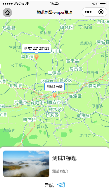
1、先看效果
uni-app (微信小程序中)

2、实现方式
- 加载地图(我用的腾讯地图)
使用uni.createMapContext创建地图
onLoad() {
			this.map.myMapObj = uni.createMapContext("myMap", this); // 得到map对象
			this.getData();//加载数据
		},
- swiper盒子放入页面,样式可根据要求自行修改
直接使用uni-app中封装的swiper,注意swiper盒子应该包含在地图map标签内部
<swiper class="swiper-box" :current="currentswiper" @change="swiperChange($event)" display-multiple-items=1>
	<block>
		<swiper-item class="swiperitem" v-for="(item,index) in markersData" :key='index'>
			<view class="swiper-box1">
				<view class="txt-img">
					<image src="https://pic.imgdb.cn/item/61ef49652ab3f51d9100dd7e.png" mode=""></image>
					<view class="txt-info">
						<text class="title">{{item.title}}</text>
						<text class="discrip">{{item.discripe}}</text>
					</view>
				</view>
				<view class="navigation" @click="handleMapLocation(item.latitude,item.longitude,item.title)">
					<text class="txt">导航</text>
					<image src="../static/lnwd-img/daohang.png" mode=""></image>
				</view>
			</view>
		</swiper-item>
	</block>
</swiper>
- 具体实现
使用map组件的@markertap点击方法,点击时调用moveToLocation方法将地图中心移动到相应标记点,然后再动态修改swiper组件的current值。swiper滑动时,使用swiper组件的@change(current 改变时会触发)方法,滑动时调用map组件的moveToLocation方法,将地图中心移动至swiper滑块对应的经纬度
markertap(e) { //标记点点击事件
		let marker = this.map.markers.find(item => {return item.id == e.detail.markerId});
		if(!marker) {
			uni.showToast({
				title: '数据加载失败',
				icon:'none',
				duration: 2000
			});
		} else {
			//移动到当前定位地点
			this.map.myMapObj.moveToLocation({
				latitude: marker.latitude,
				longitude: marker.longitude
			});
		};
		this.currentswiper = e.detail.markerId
	},
swiperChange(event) {
	//移动到当前定位地点
	console.log(event.detail.current)
	this.map.myMapObj.moveToLocation({
		latitude: this.markersData[event.detail.current]._source.latitude,
		longitude: this.markersData[event.detail.current]._source.longitude
	});
},
3、整体代码
<template>
	<view class="map-page">
		<map id="myMap" style="width: 100%; height: 90vh;" :show-location="true" :latitude="map.latitude" :longitude="map.longitude" :scale="map.scale" :markers="map.markers" :circles="map.circles" @markertap="markertap" >
			<swiper class="swiper-box" :current="currentswiper" @change="swiperChange($event)" display-multiple-items=1>
				<block>
					<swiper-item class="swiperitem" v-for="(item,index) in testData" :key='index'>
						<view class="swiper-box1">
							<view class="txt-img">
								<image src="https://pic.imgdb.cn/item/61ef49652ab3f51d9100dd7e.png" mode=""></image>
								<view class="txt-info">
									<text class="title">{{item.title}}</text>
									<text class="discrip">{{item.discripe}}</text>
								</view>
							</view>
							<view class="navigation" @click="handleMapLocation(item.latitude,item.longitude,item.title)">
								<text class="txt">导航</text>
								<image src="../static/lnwd-img/daohang.png" mode=""></image>
							</view>
						</view>
					</swiper-item>
				</block>
			</swiper>

		</map>
	</view>
</template>

<style lang="less" scoped>
	@import 'index.less';
</style>

<script>
	export default {
		data() {
			return {
				currentswiper: 0,//swiper的current,默认显示第一个
				testData: [],//swiper数据
				map: {
					myMapObj: {},
					latitude: '', //默认地址是后台返回数据的第一条
					longitude: '',
					scale: 8.5, // 默认16
					markers: [],//标记点
					marker: {}
				},
			};
		},
		onLoad() {
			this.map.myMapObj = uni.createMapContext("myMap", this); // 得到map对象
			this.getData();//加载数据
		},
		methods: {
			swiperChange(event) {
				//移动到当前定位地点
				console.log(event.detail.current)
				this.map.myMapObj.moveToLocation({
					latitude: this.markersData[event.detail.current]._source.latitude,
					longitude: this.markersData[event.detail.current]._source.longitude
				});
			},
			markertap(e) { //标记点点击事件
				let marker = this.map.markers.find(item => {return item.id == e.detail.markerId});
				if(!marker) {
					uni.showToast({
						title: '数据加载失败',
						icon:'none',
						duration: 3000
					});
				} else {
					this.map.myMapObj.moveToLocation({
						latitude: marker.latitude,
						longitude: marker.longitude
					});	//移动到当前定位地点
				};
				this.currentswiper = e.detail.markerId
			},
			getData() { //获取地图显示的数据
				uni.request({
					url: '/jiekou',//后台接口地址,根据实际需要修改
					method: 'POST',
					header:{
						'Content-Type' : 'application/json'
					},
					data: {
						data:'canshu'//需要传的参数,根据需要修改
					},
					success: res => {
						//请求成功
						console.log(res);
						this.map.latitude = res.data.data[0].latitude
						this.map.longitude = res.data.data[0].longitude
						this.map.markers = [];
						res.data.data.forEach((item, index) => {
							let marker = {
								"id": index,
								"latitude": item.latitude,
								"longitude": item.longitude,
								"width": '30rpx',
								"height": '40rpx',
								"iconPath": '../static/lnwd-img/location.png',
								"callout": {//标记点顶部气泡
									"content": item.title,
									"display": "ALWAYS",
									"padding": 6,
									"borderRadius": 5,
									"borderWidth": 1,
									"borderColor": "#3D8DFE"
								},
								"customData": {
									"title": item.title,
									"describe": item.discripe,
								}
							};
							this.map.markers.push(marker);
							this.$set(this, "markersData", res.data.data);
						});
						console.log(this.markersData, 'this.markersData')
						console.log(this.map, 'this.map')
					},
					fail: () => {}
					});
			},

			handleMapLocation(lat,long,titl) {
				console.log('进入导航')
				// 获取定位信息
				uni.getLocation({
					type: 'wgs84', //返回可以用于uni.openLocation的经纬度
					// 用户允许获取定位
					success: (res) => {
						console.log(res, '经纬度===>')
						if (res.errMsg == "getLocation:ok") {
							uni.openLocation({
								// 传入你要去的纬度
								latitude: lat,
								// 传入你要去的经度
								longitude: long,
								// 传入你要去的地址信息 不填则为空
								address: titl,
								// 缩放大小
								scale: 18,
								success: function() {
									console.log('成功的回调success');
								}
							});
						}
					},
					// 用户拒绝获取定位后 再次点击触发
					fail: function(res) {
						console.log(res)
						if (res.errMsg == "getLocation:fail auth deny") {
							uni.showModal({
								content: '检测到您没打开获取信息功能权限,是否去设置打开?',
								confirmText: "确认",
								cancelText: '取消',
								success: (res) => {
									if (res.confirm) {
										uni.openSetting({
											success: (res) => {
												console.log('确定');
											}
										})
									} else {
										console.log('取消');
										return false;
									}
								}
							})
						}
					}
				});
			},
		}
	}
</script>

华为开发者空间,是为全球开发者打造的专属开发空间,汇聚了华为优质开发资源及工具,致力于让每一位开发者拥有一台云主机,基于华为根生态开发、创新。
更多推荐


 5
5 0
0- 0


 已为社区贡献1条内容

所有评论(0)